
The Korea Meteorological Administration (KMA) officially expanded the coverage of forecast data from its self-developed Korean Integrated Model (KIM) to the Southeast Asia-Oceania (SAO) region on July 24, 2026. The move aligns with the policy direction of the World Meteorological Organization (WMO) Severe Weather Forecasting Programme (SWFP), marking an important step in sharing the Republic of Korea’s numerical weather prediction capabilities internationally.
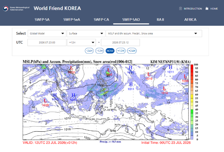
As the ninth country in the world to independently develop a global numerical weather prediction model, KMA raised the horizontal resolution of its global forecasts to 8 km in 2025, opening a new phase of higher-precision global numerical forecasting. This expansion builds on that technical expertise to provide high-quality forecast support to developing countries with limited access to meteorological information.
The new service covers 117 cities across five island nations — Brunei, Indonesia, Malaysia, Papua New Guinea, and Timor-Leste — and provides 33 types of real-time weather charts, including wind fields and temperature information at various atmospheric levels. These data can help local forecasters more effectively monitor severe weather events and issue timely early warnings.
Dr. Miseon Lee, Administrator of KMA, said the service expansion is significant as it allows the outcomes of the Korean Integrated Model, developed with the country’s own technology, to be shared with the international community and strengthens the disaster response capacity of developing countries facing difficulties due to limited access to weather information. KMA will continue to deepen cooperation with WMO and its Members and play its part in protecting life and property.
From an industry perspective, KIM’s global numerical forecasting at 8 km resolution has significantly improved the simulation capability for typhoons, severe convection, and other mesoscale and small-scale weather systems. However, a high-resolution model is only the foundation; equally critical is transforming forecast products into decision-support tools that local forecasters can use. By providing regionally customized weather charts, KMA standardizes and visualizes complex model outputs, lowering the technical barrier and enabling developing countries without high-performance computing capabilities to benefit from advanced numerical forecasts. This expansion is also the latest practice of the “Early Warnings for All” (EW4All) initiative in the Asia-Pacific region. KMA has previously provided regionally customized weather charts for three regions in Asia, and the extension to Oceania further expands the coverage of early warning services.
Source: World Meteorological Organization (WMO) (Link: https://wmo.int/media/news-from-members/kma-expands-swfp-sao-coverage)
 WMO Report Warns: Wildfires and Heatwaves Weigh on Global Ai
 Africa Early Warning Action Call Highlights Gaps in Meteorol
 Essential Autumn Maintenance Checklist for Automatic Weather